

")
Even before mandatory evacuation orders were issued on Monday, Amy Siuda and her family were preparing to leave their home in St. Petersburg, Florida. Siuda, a biological oceanographer at Eckerd College, and her family had stayed put when Hurricane Helene passed by less than 2 weeks ago and shoved more than 1 meter of storm surge onto the small peninsula across the bay from Tampa. Their house didn’t flood, but many of their neighbors’ homes did. So when she saw the projections for Hurricane Milton—including a storm surge of up to 4 meters from what’s expected to make landfall as a major hurricane—she knew it was time to go. Siuda gave her children a box and a suitcase, and said “Put stuff in here that you want to bring with us,” she recalls. “We have half a suitcase of stuffed animals.”
Just a few days earlier, Siuda had been on campus with her colleagues, assessing the damage from Helene. The school had prepared for the storm, which dealt Florida a glancing blow en route to wreak inland havoc in the Carolinas, Tennessee, Georgia, and other states thanks to its massive rainfall. At Eckerd, key research samples that needed to be kept frozen had been shipped to safe locales, and less valuable ones had been sealed in freezers that would hold their temperature well enough for a week or so without power. Buildings had been battened down. But still, the damage was extensive, she says. And just as the faculty and staff made plans to catalog and clean up the mess, they were told there would be no time—everyone had to pivot to making additional preparations for a direct hit from Milton.
As the family drove away Tuesday morning, heading for Pensacola, they passed the wreckage of Helene. “There’s piles—people’s kitchens are outside their houses in my neighborhood,” Siuda says. When Milton makes landfall, its high-speed winds will likely turn that debris into deadly projectiles.
Andrew Kruczkiewicz, a meteorologist at Columbia University who specializes in disaster risk, says researchers, government officials, and the public need to start seeing hurricanes as “compound events” instead of isolated hazards—especially as climate change increases the frequency and intensity of extreme weather. Milton would always have posed a major threat, he notes, but the recent impact of Helene has left communities more vulnerable than usual.
It has also complicated efforts to study the hurricanes—and figure out how to prepare for future storms. Earlier this week, while some researchers with the U.S. Geological Survey (USGS) analyzed data collected during Helene, others raced to repair damaged equipment and install additional wave sensors on bridges and piers along the Gulf Coast. Milton is gearing up to completely reshape Florida’s coastline, says Margaret Palmsten, an oceanographer at the agency’s St. Petersburg Coastal and Marine Science Center. The storm’s enormous waves will eat away at the beaches, she explains, and even surge over top of them. This process, known as overwash, can push sand inland, trigger widespread flooding, and even carve new paths through barrier islands. According to current USGS estimates, practically all the sandy beaches on Florida’s west coast will become inundated by Milton.
And that’ll be on top of Helene’s effects. When members of Palmsten’s team went to install wave sensors at a site in Madeira Beach, they saw the dunes “eroding down to levels we hadn’t ever seen before.” Helene already caused “historic changes” to Florida’s western coast, she says.
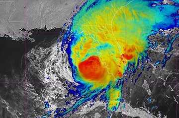
“It’s going to be one for the history books, and not in a great way,” says Jonathan Shannon, a public affairs specialist with the National Oceanic and Atmospheric Administration Aircraft Operations Center in Lakeland, Florida, from which the agency’s Hurricane Hunters fly. And he would know—Shannon flew through Milton early Monday and watched the storm intensify in real time. “We expected a high-end Category 1 [hurricane],” he says. “We went through the first time, and it was a Category 3. We went through the second time, and it was high-end Category 3. We went through the third time, and it was Category 4”—all within about 4 hours, he says. (Milton oscillated between Category 4 and 5 through late Wednesday before weakening to the Category 3 storm that’s expected to come ashore just south of Tampa.)
The flights provided essential information to inform the models used by the National Hurricane Center to forecast Milton’s path. “The satellites can only see so much,” he explains. “That’s why we fly the missions … we needed to go in there and actually measure what was happening.”
Shannon boarded that flight early Monday morning after helping his wife and two children pack what they needed from their Tampa home so they could head to West Palm Beach to weather the storm. Afterward, he drove to Sarasota to help his mother shutter her house before bringing her to join the rest of the family. He doesn’t know what either home will look like when they return. It was strange, he says, “getting to fly into a storm that then comes to visit you. The hunter becomes the hunted, as it were.”
Barnali Dixon, a geoscientist at the University of South Florida in St. Petersburg who has lived in the area for decades, is also anxiously watching the storm. She has weathered other close calls for the Tampa Bay area, including 2004’s Hurricane Charley and 2022’s Hurricane Ian. But to her, Milton feels very different. “Obviously, I’m worried,” she says, after evacuating safely yesterday outside the storm’s projected path. “My house may not be there [when I return].”
At the same time, she’s been busy laying the groundwork to collect what she hopes will be helpful data. In between Helene and Milton, she seized the opportunity to set up three new stationary cameras around the city, which take pictures of flagged poles to measure flood water height. Those images will be added to photos provided by community members using the CRIS-HAZARD app. After receiving $1.5 million from the National Science Foundation to build the app last year, Dixon and her colleagues had beta-tested and fine-tuned it, and then soft-launched it at a meeting of Pinellas County neighborhood associations on 18 September. A little over a week later, CRIS-HAZARD received reports of Helene’s storm surge from around the county. “My inner scientist said, ‘Oh hey! Some data!’ You can actually run an experiment.”
Those images and ones taken during Milton will be mined to generate fine-grained data on the flooding that occurred. “We can take those lived experiences of people and make them into data points, and then those data points can be used to calibrate and validate models,” Dixon says. She’s been remotely checking on the now 11 cameras—including one in her backyard—ahead of Milton’s arrival.
Palmsten, who has evacuated north to Panama City, is trying to look for a silver lining. “Even though this is just devastating for the scientists, for the community, we can learn something from this that will allow us to make better forecasts in the future.”
But many other researchers worry they won’t have homes to come back to once Milton departs, or that they won’t be able to remain in Florida. “I don’t think I can handle that kind of loss,” Siuda says. “It’s getting scary living where we are right now.”
